Today 30 km. Total 131km. 11hrs (0730-1750).
I woke up at 0700 and was ready to go by 0730. It is much easier when you don't have to pack everything up. The weather was overcast and it had obviously rained over night.
I started walking through Ahipara and was surprised that the body felt so good. I could feel the extra weight of the resupply but only noticed it for 10 minutes. My feet felt fine as well despite walking on sealed road.

After 2 km the rain started. For the first 10 minutes it was light drizzle which I was fine with then someone turned on the tap and it got really heavy. My top half stayed nice and dry but my shoes, socks and shorts got drenched. It stayed like this all the way to the track start. I had two offers of a lift. One guy was so confident I would take it he emptied out his boot so my pack would fit and was waiting under his boot door for me. I thanked him and explained what I was doing and that I had to walk every bit of the trail. He had never heard of the trail but was interested. Lovely guy and one of the few willing to pick up a wet hiker. The other person stopped their car and put down their window to ask and looked confused when I said no thanks.
At the start of the track I had a break before advancing into the thick jungle of Northland bush... via the beautifully constructed wooden steps.

The first part of the track is a typical NZ backcountry tramping track but it was well maintained and well marked.


I loved being back in the bush again. The colours, textures, smells and sounds are distinctly NZ Bush and it was great. I had a smile on my face as i was loving it so much. At least in the bush there are no surprises and no rouge waves out to get me.
The rain stopped and I quickly got hot so the jacket came off though I stayed wet for a while by brushing past the wet trees. Every now and again I caught glimpses of a view. The beach to one side and bush ranges the other side. I could still hear the beach for a while and then there was silence for the first time in 4 days no sound of the waves. Instead I now had the more delicate sound of the water dropping off leaves and birds chirping though I couldn't see any.
After 1 1/2 hours I arrived at the Kaouri Grove and there were heaps of these majestic trees. I always forget how amazing they are with their age and size. Makes you realise how short a time we (humans) have been in NZ.


For some reason as I was walking I got a saying in my head that at would probably make a good chorus for a song about TA. It was very simple and went like this "up and down, up and down, why go around when you can go up and down". It was in reference to normal ridge travel where you are always going up and down. I managed to get through all of 90 Mile Beach without something stuck in my head but 2 hours in the bush and there it is.
The track started to get a little boggy and then more and more so. It also passed through another stand of Kauri.


The track continued to an old 4wd track which was largely steam for most of it.


There was lots of mud as well. There had been muddy patches but this took it to a whole new level. It was interesting the different coloured mud on this track. There was brown, yellow, orange, red and white mud.


I then came to a signpost which said 4 hours to Diggers Road and 4 hours back the way I had come so this was the half way point. I was 1 hour under the DOC estimate time already
The track then became even more wet and muddy as it went along a ridge then climbed to the high point at 567m. This was marked by a trig but this was not much use as a navigation aid as it was dwarfed by the trees around it. Just before this there was an opening in the trees and the view was back over Ahipara and the ocean.


The track then went down very steeply and there was some evidence of the damage from the recent storm but DOC have done a fantastic job fixing it or re-routing the track. The last 300 metres were unbelievably slippery. I could not get any traction and was sliding a lot. I had to hang on to tree trunks and Supple Jack (a vine) to safely make my way down. Thankfully I managed this without any falls.

It was then down a farm track to Diggers Road and the end of the Herekino Track. I completed this in 6 hours exactly (DOC estimate 8 hours).

I then followed this gravel road for 1.5 km to the turnoff to the forest though one side of the road had been cut down. Along this bit of road I saw a Tui, Pheasant, Yellow Head, Wood Pigeon and Fantail. Not bad for a 3 km stretch of pine forest.


Though the forest was a gravel road there were meant to be orange markers but I only saw the one at the start. I came to a skid site and the road then headed up hill and to the right which I was not expecting. I stopped and washed the mud off my legs and shoes then headed up the hill.

Half way up I thought I should have checked for markers at the skid site but I wasn't going back down. I went past a road not on the map and kept climbing before heading back down and I noticed an older looking track heading left which I figured was the original one on the map and the main track was new, probably put in during the recent logging. The old track headed down to a beautiful grassy meadow which would have been lovely to camp at. I wanted to keep going another hour so I passed this up though when stopping for some water I got attacked by Sandflys so was glad to keep going. The track crossed a creek up to my mid thigh which I guess is why they re routed the road. It then headed uphill and there was an orange marker which was a relief. 50 meters on was the road and I headed left intending to walk another 40 minutes.
Both sides of the road had bush but I struggled to find a campsite as it was either to steep or to wet. Eventually I scrambled up a bank to what looked good but was too wet. I decided to go further up and found a nice spot but across the fence was the perfect spot so I climbed over and set up camp.

As I was limited on water I went for a small pumpkin soup followed by Bobotie freezedry, which was lovely, followed by a lollie for desert.
As I write this I can hear a Kiwi calling which is fantastic
Lots of other birds were making a racket but now it has gone dark they have gone quiet.
Answer: Kauri bark
Hints of the day
1. Water. There is a stream after the Kaouri Grove. There were also a couple of streams just off the 4wd track, With all the recent reason water is not a problem anywhere on the track and there is something every few km along the track.
2. The is a nice campspot at the trig 567m just before the down Hill bit.
3. When walking look 2-3 metres ahead. This lets you plan ahead where you are going to step. The human mind is amazing and it memorizes the 2 meters and reacts as required while you are looking ahead.
4. When your walking poles get stuck in the mud just rotate them before you pull and this releases the suction.
I woke up at 0700 and was ready to go by 0730. It is much easier when you don't have to pack everything up. The weather was overcast and it had obviously rained over night.
I started walking through Ahipara and was surprised that the body felt so good. I could feel the extra weight of the resupply but only noticed it for 10 minutes. My feet felt fine as well despite walking on sealed road.
The sights of Ahipara. I can see why they have trouble with people wanting to use this beautiful building
After 2 km the rain started. For the first 10 minutes it was light drizzle which I was fine with then someone turned on the tap and it got really heavy. My top half stayed nice and dry but my shoes, socks and shorts got drenched. It stayed like this all the way to the track start. I had two offers of a lift. One guy was so confident I would take it he emptied out his boot so my pack would fit and was waiting under his boot door for me. I thanked him and explained what I was doing and that I had to walk every bit of the trail. He had never heard of the trail but was interested. Lovely guy and one of the few willing to pick up a wet hiker. The other person stopped their car and put down their window to ask and looked confused when I said no thanks.
At the start of the track I had a break before advancing into the thick jungle of Northland bush... via the beautifully constructed wooden steps.
The start of the bush. Only 8 hours to the end
The first part of the track is a typical NZ backcountry tramping track but it was well maintained and well marked.
A little steep but nice and open
One of the few deadfall left
Beautiful in the mist
I loved being back in the bush again. The colours, textures, smells and sounds are distinctly NZ Bush and it was great. I had a smile on my face as i was loving it so much. At least in the bush there are no surprises and no rouge waves out to get me.
The rain stopped and I quickly got hot so the jacket came off though I stayed wet for a while by brushing past the wet trees. Every now and again I caught glimpses of a view. The beach to one side and bush ranges the other side. I could still hear the beach for a while and then there was silence for the first time in 4 days no sound of the waves. Instead I now had the more delicate sound of the water dropping off leaves and birds chirping though I couldn't see any.
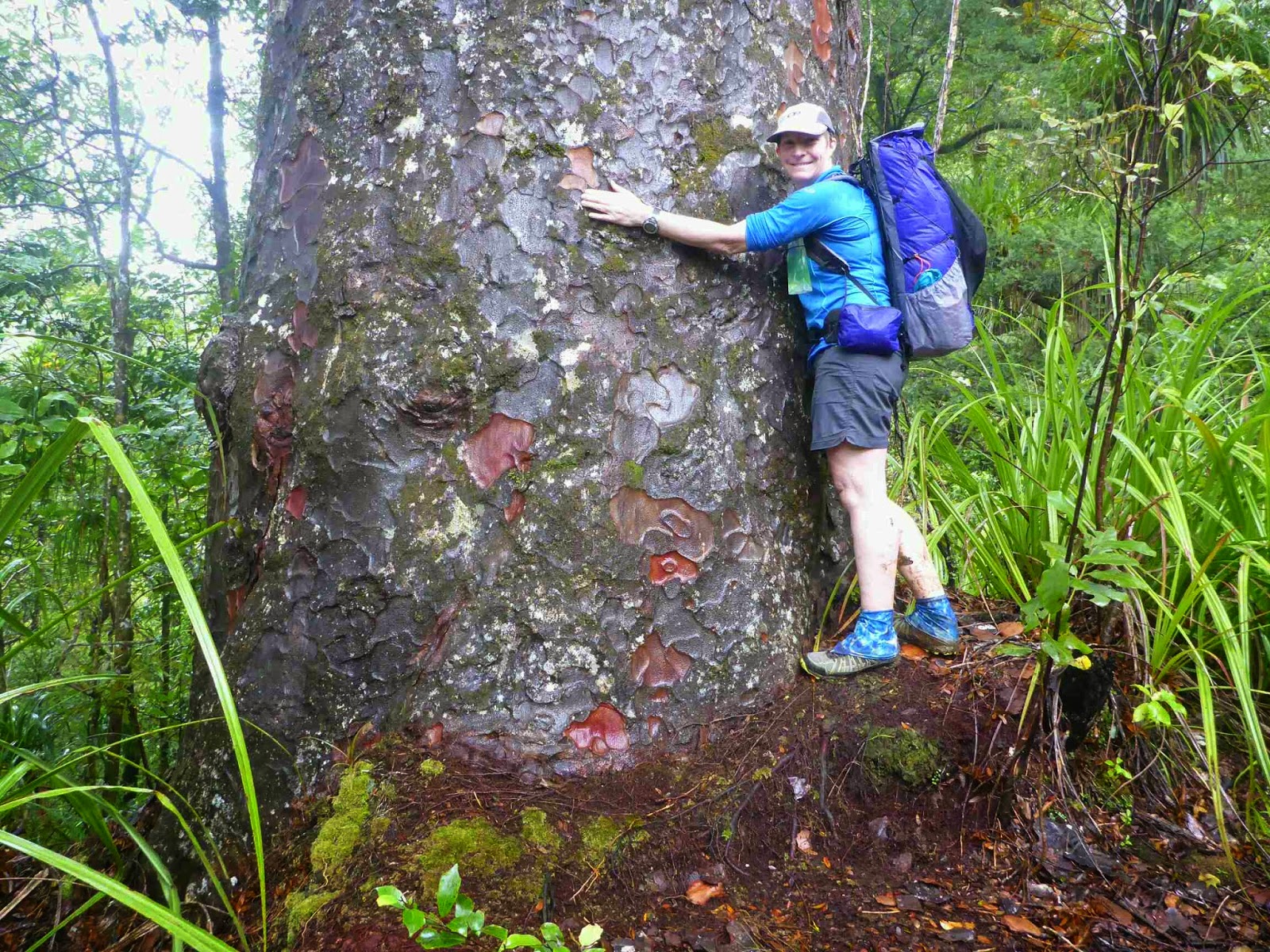
After 1 1/2 hours I arrived at the Kaouri Grove and there were heaps of these majestic trees. I always forget how amazing they are with their age and size. Makes you realise how short a time we (humans) have been in NZ.
This is one of the smaller younger Kauri
Impressive Kauri
For some reason as I was walking I got a saying in my head that at would probably make a good chorus for a song about TA. It was very simple and went like this "up and down, up and down, why go around when you can go up and down". It was in reference to normal ridge travel where you are always going up and down. I managed to get through all of 90 Mile Beach without something stuck in my head but 2 hours in the bush and there it is.
The track started to get a little boggy and then more and more so. It also passed through another stand of Kauri.
Just a little mud
Yes I am secretly a tree hugger. Who can resist with trees like these
Can you guess what this is? (Answer at end)
The track continued to an old 4wd track which was largely steam for most of it.
The Start of the 4wd track
There were some nice bits
There was lots of mud as well. There had been muddy patches but this took it to a whole new level. It was interesting the different coloured mud on this track. There was brown, yellow, orange, red and white mud.
White mud
Brown mud
Yellow mud
Red mud
Black mud
I then came to a signpost which said 4 hours to Diggers Road and 4 hours back the way I had come so this was the half way point. I was 1 hour under the DOC estimate time already
The track then became even more wet and muddy as it went along a ridge then climbed to the high point at 567m. This was marked by a trig but this was not much use as a navigation aid as it was dwarfed by the trees around it. Just before this there was an opening in the trees and the view was back over Ahipara and the ocean.
Nice stream down the track
The first log crossing
Spooky old huts in the mist
The view back to the ocean
Going down
Punga
One of the few overgrown bits
The track then went down very steeply and there was some evidence of the damage from the recent storm but DOC have done a fantastic job fixing it or re-routing the track. The last 300 metres were unbelievably slippery. I could not get any traction and was sliding a lot. I had to hang on to tree trunks and Supple Jack (a vine) to safely make my way down. Thankfully I managed this without any falls.
The very slippery descent
It was then down a farm track to Diggers Road and the end of the Herekino Track. I completed this in 6 hours exactly (DOC estimate 8 hours).
Done in 6 hours
I then followed this gravel road for 1.5 km to the turnoff to the forest though one side of the road had been cut down. Along this bit of road I saw a Tui, Pheasant, Yellow Head, Wood Pigeon and Fantail. Not bad for a 3 km stretch of pine forest.
Tui
The stile to nowhere
Though the forest was a gravel road there were meant to be orange markers but I only saw the one at the start. I came to a skid site and the road then headed up hill and to the right which I was not expecting. I stopped and washed the mud off my legs and shoes then headed up the hill.
Just a little muddy
Half way up I thought I should have checked for markers at the skid site but I wasn't going back down. I went past a road not on the map and kept climbing before heading back down and I noticed an older looking track heading left which I figured was the original one on the map and the main track was new, probably put in during the recent logging. The old track headed down to a beautiful grassy meadow which would have been lovely to camp at. I wanted to keep going another hour so I passed this up though when stopping for some water I got attacked by Sandflys so was glad to keep going. The track crossed a creek up to my mid thigh which I guess is why they re routed the road. It then headed uphill and there was an orange marker which was a relief. 50 meters on was the road and I headed left intending to walk another 40 minutes.
Both sides of the road had bush but I struggled to find a campsite as it was either to steep or to wet. Eventually I scrambled up a bank to what looked good but was too wet. I decided to go further up and found a nice spot but across the fence was the perfect spot so I climbed over and set up camp.
Night 6
As I was limited on water I went for a small pumpkin soup followed by Bobotie freezedry, which was lovely, followed by a lollie for desert.
As I write this I can hear a Kiwi calling which is fantastic
Lots of other birds were making a racket but now it has gone dark they have gone quiet.
Answer: Kauri bark
Hints of the day
1. Water. There is a stream after the Kaouri Grove. There were also a couple of streams just off the 4wd track, With all the recent reason water is not a problem anywhere on the track and there is something every few km along the track.
2. The is a nice campspot at the trig 567m just before the down Hill bit.
3. When walking look 2-3 metres ahead. This lets you plan ahead where you are going to step. The human mind is amazing and it memorizes the 2 meters and reacts as required while you are looking ahead.
4. When your walking poles get stuck in the mud just rotate them before you pull and this releases the suction.
No comments:
Post a Comment